File:Albania relief location map.jpg

Nea wohwɛ yi ne tibea: 410 × 600 pixels. resolutions: 164 × 240 pixels | 328 × 480 pixels | 685 × 1,002 pixels. Foforɔ
Krataa no ankasa (685 × 1,002 pixels, file size: 406 KB, MIME type: image/jpeg)
Tɔ fa
| Ɛmu nkyerɛkyere mu |
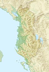
English: Location map of Albania.
Equirectangular projection. Strechted by 130.0%. Geographic limits of the map: * N: 42.9° N * S: 39.3° N * W: 18.3° E * E: 21.5° EMade with Natural Earth. Free vector and raster map data @ naturalearthdata.com. |
| Da | |
| Beaɛ a ɛfiri | Wo ankasa w'adwuma |
| Ɔtwerɛfoɔ | Uwe Dedering |
Tumidie krataa
I, the copyright holder of this work, hereby publish it under the following licenses:
This file is licensed under the Creative Commons Attribution-Share Alike 3.0 Unported license.
- Wo de woho:
- sɛ wo bɛ kyɛ – to copy, distribute and transmit the work
- to remix – Ma dwumadie no mfa
- Ɛwɔ saa mbra yi ase:
- Nea ɛnam so – Ɛsɛ sɛ wo de nnidi, kyerɛ beaɛ a tumidie krataa no wɔ, na san kyerɛ sɛ nsesae bi aba mu anaa. Ɛsɛ sɛ wo kyerɛ ɛwɔ kwan pa so, na ɛmom ɛnyɛ ɔkwan a ɛkyerɛsɛ nea tumidie krataa no yɛ ne de no agye atum sɛ fa yɛ adwuma.
- share alike – If you remix, transform, or build upon the material, you must distribute your contributions under the same or compatible license as the original.

|
Permission is granted to copy, distribute and/or modify this document under the terms of the GNU Free Documentation License, Version 1.2 or any later version published by the Free Software Foundation; with no Invariant Sections, no Front-Cover Texts, and no Back-Cover Texts. A copy of the license is included in the section entitled GNU Free Documentation License. |
Wobɛtumi ayi tumidie krataa a wopɛ
Kratafa ne ho abakɔsɛm
Mia ɛda/berɛ no so na hwɛ sɛnea krataa no baeɛ wo saa berɛ nom
| Da/Mmere | Tɔfabɔ | Akwan ahodoɔ | Odwumdini | Adwenkyerɛ | |
|---|---|---|---|---|---|
| nea ɛkɔ so | 11:45, 14 Ɔbɛnem 2010 | | 685 × 1,002 (406 KB) | Uwe Dedering | {{Information |Description={{en|1=Location map of Albania. Equirectangular projection. Strechted by 130.0%. Geographic limits of the map: * N: 42.9° N * S: 39.3° N * W: 18.3° E * E: 21.5° E Made with Natural Earth. Free vector and raster map dat |
Nkrataa a wɔde di dwuma
Nea ɛdidisoɔ yi kratafa dwumadie this file:
Nea wiase nyinaa de yɛ adwuma
Wikis a edidi so yi de di dwuma:
- Yɛ de ayɛ adwuma wɔ azb.wikipedia.org
- Yɛ de ayɛ adwuma wɔ ban.wikipedia.org
- Taman Nasional Shebenik-Jabllanicë
- Taman Nasional Prespa (Albania)
- Taman Nasional Divjakë-Karavasta
- Taman Nasional Llogara
- Taman Nasional Butrint
- Taman Nasional Dajti
- Taman Nasional Tomorr
- Taman Nasional Hotovë-Dangelli
- Taman Segara Karaburun-Sazan
- Taman Nasional Tukad Liar Vjosa
- Taman Nasional Gunung Lurë-Dejës
- Yɛ de ayɛ adwuma wɔ bcl.wikipedia.org
- Yɛ de ayɛ adwuma wɔ bs.wikipedia.org
- Yɛ de ayɛ adwuma wɔ bxr.wikipedia.org
- Yɛ de ayɛ adwuma wɔ ca.wikipedia.org
- Yɛ de ayɛ adwuma wɔ ceb.wikipedia.org
- Yɛ de ayɛ adwuma wɔ ce.wikipedia.org
- Yɛ de ayɛ adwuma wɔ ckb.wikipedia.org
- Yɛ de ayɛ adwuma wɔ de.wikipedia.org
- Yɛ de ayɛ adwuma wɔ diq.wikipedia.org
- Yɛ de ayɛ adwuma wɔ dsb.wikipedia.org
- Yɛ de ayɛ adwuma wɔ eo.wikivoyage.org
- Yɛ de ayɛ adwuma wɔ es.wikipedia.org
- Lago Shkodër
- Monte Korab
- Cresta del Lago
- Isla de Sazan
- Plantilla:Mapa de localización de Albania
- Monte Dajt
- Parque nacional de Thethi
- Parque nacional del valle de Valbona
- Wikiproyecto:Ilustración/Taller de Cartografía/Realizaciones/Europa
- Valle de Drino
- Cordillera de Nemërçkë
- Monte Çika
- Parque nacional Tomorr
- Gryka e Hapët
- Parque natural regional de Nikaj-Mërtur
- Maja e Thatë
- Montañas Korab
View more global usage of this file.