File:EU-Croatia.svg

Size of this PNG preview of this SVG file: 713 × 600 pixels. resolutions: 285 × 240 pixels | 571 × 480 pixels | 913 × 768 pixels | 1,218 × 1,024 pixels | 2,435 × 2,048 pixels | 2,045 × 1,720 pixels. Foforɔ
Krataa no ankasa (SVG file, nominally 2,045 × 1,720 pixels, file size: 7.33 MB)
Tɔ fa
| Ɛmu nkyerɛkyere mu |
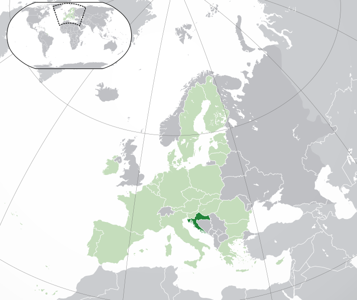
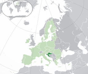
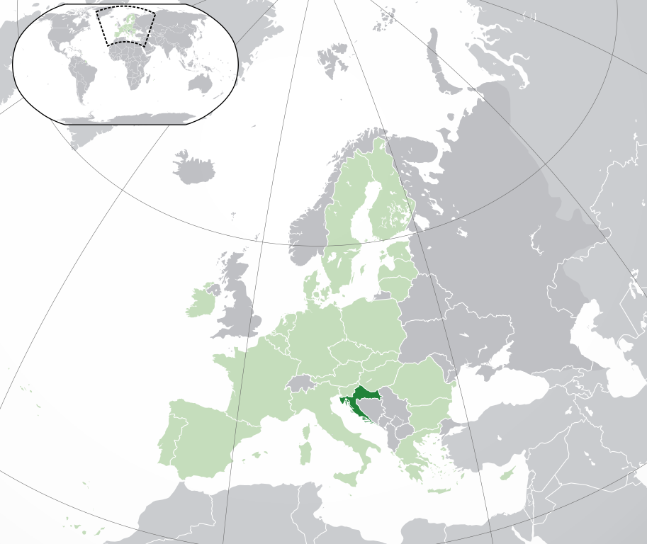
Français : (Vert) Croatie
(Vert clair) : Union Européenne (UE) (Gris) : Europe (Gris clair) : Région avoisinanteEnglish: (Green) : Croatia
(Light-green) : The European Union (EU) (Grey) : Europe (Light grey) : The surrounding region. |
| Da | |
| Beaɛ a ɛfiri | Wo ankasa w'adwuma |
| Ɔtwerɛfoɔ | {{Atoine85}} |
| Other versions |
|
| SVG genesis |


Tumidie krataa
I, the copyright holder of this work, hereby publish it under the following license:
This file is licensed under the Creative Commons Attribution-Share Alike 3.0 Unported license.
- Wo de woho:
- sɛ wo bɛ kyɛ – to copy, distribute and transmit the work
- to remix – Ma dwumadie no mfa
- Ɛwɔ saa mbra yi ase:
- Nea ɛnam so – Ɛsɛ sɛ wo de nnidi, kyerɛ beaɛ a tumidie krataa no wɔ, na san kyerɛ sɛ nsesae bi aba mu anaa. Ɛsɛ sɛ wo kyerɛ ɛwɔ kwan pa so, na ɛmom ɛnyɛ ɔkwan a ɛkyerɛsɛ nea tumidie krataa no yɛ ne de no agye atum sɛ fa yɛ adwuma.
- share alike – If you remix, transform, or build upon the material, you must distribute your contributions under the same or compatible license as the original.
Kratafa ne ho abakɔsɛm
Mia ɛda/berɛ no so na hwɛ sɛnea krataa no baeɛ wo saa berɛ nom
| Da/Mmere | Tɔfabɔ | Akwan ahodoɔ | Odwumdini | Adwenkyerɛ | |
|---|---|---|---|---|---|
| nea ɛkɔ so | 04:43, 1 Ogyefuo 2020 | | 2,045 × 1,720 (7.33 MB) | Rob984 | UK and Gibraltar have left the EU. New base which includes all of Portugal's islands within frame, as well as Arctic Russian islands part of Europe. Also fixed Flevoland in the Netherlands. |
| 16:54, 25 Ahinime 2016 |  | 2,045 × 1,720 (7.32 MB) | Giorgi Balakhadze | fix | |
| 16:37, 25 Ahinime 2016 |  | 2,045 × 1,720 (7.33 MB) | Giorgi Balakhadze | Rv of sockpuppet and per COM:OVERWRITE | |
| 16:26, 18 Ɔbɛnem 2015 |  | 2,045 × 1,720 (7.38 MB) | Mapclean | Reverted to Leftcry's version, please go to your talk page | |
| 14:03, 21 Ogyefuo 2015 |  | 2,044 × 1,719 (2.03 MB) | VS6507 | Spain. Greece. Slovakia. Cyprus. Romania VETO | |
| 19:35, 16 Obubuo 2014 |  | 2,045 × 1,720 (7.38 MB) | Leftcry | Reverted to version as of 22:33, 18 October 2014 Please go to your talk page | |
| 16:21, 16 Obubuo 2014 |  | 2,044 × 1,719 (2.03 MB) | A2D2 | The map must show the original de-jure status with no breakaway regions, as it was originally created. An alternative map showing the de-facto status with breakaway regions needs to created instead. | |
| 15:42, 16 Obubuo 2014 |  | 2,045 × 1,720 (7.38 MB) | A2D2 | Reverted to version as of 12:10, 16 August 2014 | |
| 22:33, 18 Ahinime 2014 |  | 2,045 × 1,720 (7.38 MB) | Leftcry | Minor fix | |
| 12:10, 16 Ɔsanaa 2014 |  | 2,045 × 1,720 (7.38 MB) | DIREKTOR | Fixed overview. |
Nkrataa a wɔde di dwuma
Nea ɛdidisoɔ yi kratafa dwumadie this file:
Nea wiase nyinaa de yɛ adwuma
Wikis a edidi so yi de di dwuma:
- Yɛ de ayɛ adwuma wɔ ace.wikipedia.org
- Yɛ de ayɛ adwuma wɔ ady.wikipedia.org
- Yɛ de ayɛ adwuma wɔ af.wikipedia.org
- Yɛ de ayɛ adwuma wɔ ami.wikipedia.org
- Yɛ de ayɛ adwuma wɔ ar.wikipedia.org
- كرواتيا
- مستخدم:ElWaliElAlaoui/ملعب 8
- معاملة المثليين في كرواتيا
- مستخدم:جار الله/قائمة صور مقالات العلاقات الثنائية
- العلاقات الأمريكية الكرواتية
- العلاقات الأنغولية الكرواتية
- العلاقات الكرواتية الكورية الجنوبية
- العلاقات الإريترية الكرواتية
- العلاقات السويسرية الكرواتية
- العلاقات الألمانية الكرواتية
- العلاقات الكرواتية الليختنشتانية
- العلاقات البوليفية الكرواتية
- العلاقات الكرواتية الموزمبيقية
- العلاقات الألبانية الكرواتية
- العلاقات البلجيكية الكرواتية
- العلاقات الإثيوبية الكرواتية
- العلاقات البيلاروسية الكرواتية
- العلاقات الطاجيكستانية الكرواتية
- العلاقات الروسية الكرواتية
- العلاقات الرومانية الكرواتية
- العلاقات الأرجنتينية الكرواتية
- العلاقات الغامبية الكرواتية
- العلاقات القبرصية الكرواتية
- العلاقات السيراليونية الكرواتية
- العلاقات الكرواتية النيبالية
- العلاقات الكرواتية الليبيرية
- العلاقات التشيكية الكرواتية
- العلاقات الكرواتية الميانمارية
- العلاقات الكرواتية الكندية
- العلاقات الزيمبابوية الكرواتية
- العلاقات الإسرائيلية الكرواتية
- العلاقات البالاوية الكرواتية
- العلاقات الكرواتية المالية
- العلاقات الكرواتية النيجيرية
- العلاقات اليمنية الكرواتية
- العلاقات الفانواتية الكرواتية
- العلاقات الغابونية الكرواتية
- العلاقات البنمية الكرواتية
- العلاقات الكرواتية الكوبية
- العلاقات الجورجية الكرواتية
- العلاقات الكرواتية الكورية الشمالية
- العلاقات الهندية الكرواتية
- العلاقات اليابانية الكرواتية
- العلاقات الإيطالية الكرواتية
- العلاقات الكرواتية الناوروية
- العلاقات الأسترالية الكرواتية
View more global usage of this file.