File:EU-Denmark.svg

Size of this PNG preview of this SVG file: 713 × 600 pixels. resolutions: 285 × 240 pixels | 571 × 480 pixels | 913 × 768 pixels | 1,218 × 1,024 pixels | 2,435 × 2,048 pixels | 2,045 × 1,720 pixels. Foforɔ
Krataa no ankasa (SVG file, nominally 2,045 × 1,720 pixels, file size: 7.33 MB)
Tɔ fa
| Ɛmu nkyerɛkyere mu |
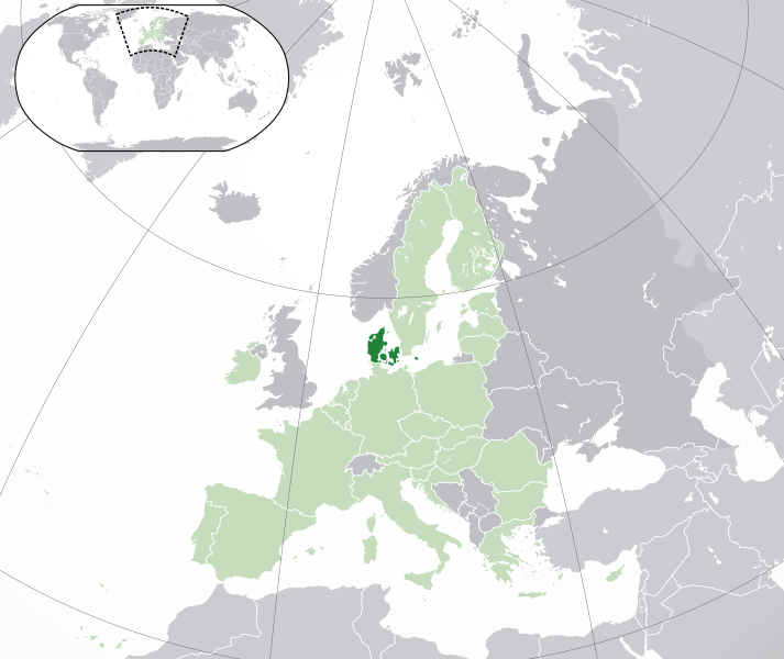
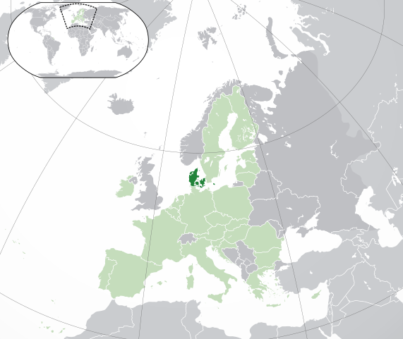
English: (Dark-Green) Denmark. (Light-Green) The rest of the European Union (EU). (Dark-gray) The rest of Europe. (Light-gray) The surrounding region.
See also: |
| SVG genesis | |
| Da | |
| Beaɛ a ɛfiri | Own work based on: Location European nation states.svg |
| Ɔtwerɛfoɔ | NuclearVacuum |
| Other versions |
|
| SVG genesis |


Tumidie krataa
I, the copyright holder of this work, hereby publish it under the following licenses:
This file is licensed under the Creative Commons Attribution-Share Alike 3.0 Unported license.
- Wo de woho:
- sɛ wo bɛ kyɛ – to copy, distribute and transmit the work
- to remix – Ma dwumadie no mfa
- Ɛwɔ saa mbra yi ase:
- Nea ɛnam so – Ɛsɛ sɛ wo de nnidi, kyerɛ beaɛ a tumidie krataa no wɔ, na san kyerɛ sɛ nsesae bi aba mu anaa. Ɛsɛ sɛ wo kyerɛ ɛwɔ kwan pa so, na ɛmom ɛnyɛ ɔkwan a ɛkyerɛsɛ nea tumidie krataa no yɛ ne de no agye atum sɛ fa yɛ adwuma.
- share alike – If you remix, transform, or build upon the material, you must distribute your contributions under the same or compatible license as the original.

|
Permission is granted to copy, distribute and/or modify this document under the terms of the GNU Free Documentation License, Version 1.2 or any later version published by the Free Software Foundation; with no Invariant Sections, no Front-Cover Texts, and no Back-Cover Texts. A copy of the license is included in the section entitled GNU Free Documentation License. |
Wobɛtumi ayi tumidie krataa a wopɛ
Kratafa ne ho abakɔsɛm
Mia ɛda/berɛ no so na hwɛ sɛnea krataa no baeɛ wo saa berɛ nom
| Da/Mmere | Tɔfabɔ | Akwan ahodoɔ | Odwumdini | Adwenkyerɛ | |
|---|---|---|---|---|---|
| nea ɛkɔ so | 04:49, 1 Ogyefuo 2020 | | 2,045 × 1,720 (7.33 MB) | Rob984 | UK and Gibraltar have left the EU. New base which includes all of Portugal's islands within frame, as well as Arctic Russian islands part of Europe. Also fixed Flevoland in the Netherlands. |
| 19:24, 25 Ahinime 2016 |  | 2,045 × 1,720 (7.32 MB) | Giorgi Balakhadze | fix | |
| 16:37, 25 Ahinime 2016 |  | 2,045 × 1,720 (7.33 MB) | Giorgi Balakhadze | Rv of sockpuppet and per COM:OVERWRITE | |
| 14:46, 21 Ogyefuo 2015 |  | 2,045 × 1,720 (7.38 MB) | Hazhk | Reverted to version as of 19:20, 19 November 2014 | |
| 14:05, 21 Ogyefuo 2015 |  | 2,045 × 1,720 (7.38 MB) | VS6507 | Spain. Greece. Slovakia. Cyprus. Romania VETO | |
| 19:20, 19 Obubuo 2014 |  | 2,045 × 1,720 (7.38 MB) | Leftcry | Reverted to version as of 19:36, 16 November 2014 Stop making such edits without consensus! Start a discussion on the talk page first! | |
| 11:09, 19 Obubuo 2014 |  | 2,045 × 1,720 (7.38 MB) | Mondolkiri1 | Correcting one island in Norway, therefore, also in the Nordic Council | |
| 10:30, 19 Obubuo 2014 |  | 2,045 × 1,720 (7.38 MB) | Mondolkiri1 | Corrections about some islands belonging to Norway, therefore, to the Nordic Council. | |
| 10:22, 19 Obubuo 2014 |  | 2,045 × 1,720 (7.38 MB) | Mondolkiri1 | Correction about some islands in Norway, therefore, in the Nordic Council | |
| 06:45, 19 Obubuo 2014 |  | 2,045 × 1,720 (7.38 MB) | Mondolkiri1 | Reverted to version as of 21:59, 18 November 2014 Sorry but this map is far more logic since Greenland and the Faroe Islands belong to Denmark and Nordic Council but not to EU! Don't be like an Eurocrat supremacist, please! |
Nkrataa a wɔde di dwuma
Nea ɛdidisoɔ yi kratafa dwumadie this file:
Nea wiase nyinaa de yɛ adwuma
Wikis a edidi so yi de di dwuma:
- Yɛ de ayɛ adwuma wɔ ady.wikipedia.org
- Yɛ de ayɛ adwuma wɔ af.wikipedia.org
- Yɛ de ayɛ adwuma wɔ ar.wikipedia.org
- الدنمارك
- بوابة:الدنمارك/واجهة
- بوابة:الدنمارك
- مستخدم:ElWaliElAlaoui/ملعب 8
- معاملة المثليين في الدنمارك
- مستخدم:جار الله/قائمة صور مقالات العلاقات الثنائية
- العلاقات الأنغولية الدنماركية
- العلاقات الدنماركية الكورية الجنوبية
- العلاقات الدنماركية الإريترية
- العلاقات الدنماركية السويسرية
- العلاقات الدنماركية الليختنشتانية
- العلاقات الدنماركية البوليفية
- العلاقات الدنماركية الموزمبيقية
- العلاقات الألبانية الدنماركية
- العلاقات الدنماركية البلجيكية
- العلاقات الدنماركية الإثيوبية
- العلاقات الدنماركية البيلاروسية
- العلاقات الدنماركية الطاجيكستانية
- العلاقات الدنماركية الرومانية
- العلاقات الأرجنتينية الدنماركية
- العلاقات الدنماركية الغامبية
- العلاقات الدنماركية القبرصية
- العلاقات الدنماركية السيراليونية
- العلاقات الدنماركية النيبالية
- العلاقات الدنماركية الليبيرية
- العلاقات التشيكية الدنماركية
- العلاقات الدنماركية الميانمارية
- العلاقات الدنماركية الكندية
- العلاقات الدنماركية الزيمبابوية
- العلاقات الدنماركية الإسرائيلية
- العلاقات الدنماركية البالاوية
- العلاقات الدنماركية المالية
- العلاقات الدنماركية النيجيرية
- العلاقات الدنماركية اليمنية
- العلاقات الدنماركية الفانواتية
- العلاقات الدنماركية الغابونية
- العلاقات الدنماركية البنمية
- العلاقات الدنماركية الكوبية
- العلاقات الدنماركية الجورجية
- العلاقات الدنماركية التونسية
- العلاقات الدنماركية الكورية الشمالية
- العلاقات الدنماركية الهندية
- العلاقات الدنماركية اليابانية
- العلاقات الدنماركية الإيطالية
- العلاقات الدنماركية الناوروية
- العلاقات الأسترالية الدنماركية
- العلاقات الدنماركية الزامبية
- العلاقات الدنماركية الفيجية
View more global usage of this file.