File:Melbourne yarra twilight.jpg

Nea wohwɛ yi ne tibea: 800 × 369 pixels. resolutions: 320 × 148 pixels | 640 × 295 pixels | 1,517 × 700 pixels. Foforɔ
Krataa no ankasa (1,517 × 700 pixels, file size: 397 KB, MIME type: image/jpeg)
Tɔ fa
| Ɛmu nkyerɛkyere mu |
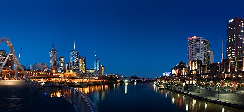
English: A panorama of Melbourne's Yarra River at twilight, showing the Central Business District on the left and the Southbank entertainment district on the right. (Inspired by a previous panorama I took at night. I wanted to revisit the scene with less harsh light) |
| Da | 26 Ɔsanaa 2005 (according to Exif data) |
| Beaɛ a ɛfiri | Self-published work by User:Diliff |
| Ɔtwerɛfoɔ | Diliff |
|
| Camera location | | View this and other nearby images on: OpenStreetMap |
|---|
I, the copyright holder of this work, hereby publish it under the following licenses:

|
Permission is granted to copy, distribute and/or modify this document under the terms of the GNU Free Documentation License, Version 1.2 or any later version published by the Free Software Foundation; with no Invariant Sections, no Front-Cover Texts, and no Back-Cover Texts. A copy of the license is included in the section entitled GNU Free Documentation License. |
| This file is licensed under the Creative Commons Attribution-Share Alike 3.0 Unported license. | ||
| ||
| This licensing tag was added to this file as part of the GFDL licensing update. |
This file is licensed under the Creative Commons Attribution-Share Alike 2.5 Generic license.
- Wo de woho:
- sɛ wo bɛ kyɛ – to copy, distribute and transmit the work
- to remix – Ma dwumadie no mfa
- Ɛwɔ saa mbra yi ase:
- Nea ɛnam so – Ɛsɛ sɛ wo de nnidi, kyerɛ beaɛ a tumidie krataa no wɔ, na san kyerɛ sɛ nsesae bi aba mu anaa. Ɛsɛ sɛ wo kyerɛ ɛwɔ kwan pa so, na ɛmom ɛnyɛ ɔkwan a ɛkyerɛsɛ nea tumidie krataa no yɛ ne de no agye atum sɛ fa yɛ adwuma.
- share alike – If you remix, transform, or build upon the material, you must distribute your contributions under the same or compatible license as the original.
Wobɛtumi ayi tumidie krataa a wopɛ
Kratafa ne ho abakɔsɛm
Mia ɛda/berɛ no so na hwɛ sɛnea krataa no baeɛ wo saa berɛ nom
| Da/Mmere | Tɔfabɔ | Akwan ahodoɔ | Odwumdini | Adwenkyerɛ | |
|---|---|---|---|---|---|
| nea ɛkɔ so | 11:24, 26 Ɔsanaa 2005 | | 1,517 × 700 (397 KB) | Diliff | A panorama of Melbourne's Yarra River at twilight, showing the Central Business District on the left and the Southbank entertainment district on the right. (Inspired by a previous panorama I took at night. I wanted to revisit the scene with less harsh lig |
Nkrataa a wɔde di dwuma
Nkratafa biara nni hɔ a ɛde wei yɛ adwuma.
Nea wiase nyinaa de yɛ adwuma
Wikis a edidi so yi de di dwuma:
- Yɛ de ayɛ adwuma wɔ bs.wikipedia.org
- Yɛ de ayɛ adwuma wɔ da.wikipedia.org
- Yɛ de ayɛ adwuma wɔ de.wikipedia.org
- Yɛ de ayɛ adwuma wɔ de.wikivoyage.org
- Yɛ de ayɛ adwuma wɔ eml.wikipedia.org
- Yɛ de ayɛ adwuma wɔ en.wikipedia.org
- Yarra River
- History of Melbourne
- User:Ceejayoz
- User:Evan C
- Wikipedia:Featured pictures thumbs/03
- Wikipedia:Featured picture candidates/Yarra Panorama
- Wikipedia:Featured picture candidates/October-2005
- User:Diliff
- Tourism in Melbourne
- Wikipedia:Wikipedia Signpost/2005-10-24/Features and admins
- User:Cyde/Featured pictures
- Wikipedia:Picture of the day/January 2006
- Wikipedia:Picture of the day/January 14, 2006
- Wikipedia:POTD/January 14, 2006
- Wikipedia:Today's second feature/January 14, 2006
- User talk:Diliff/Archive1
- Wikipedia:WikiProject Urban studies and planning
- Wikipedia:Featured pictures/Places/Panorama
- Portal:Architecture/Townscape images
- Portal:Australia/Featured picture/2007
- User:Crancon
- Portal:Australia/Featured picture/Week 48, 2007
- Talk:Melbourne/Archive 6
- Wikipedia:WikiProject Rivers/Recognized content
- Wikipedia:WikiProject Australia/Featured and good content
- Wikipedia:WikiProject Australia/2.0/About
- Portal:Australia/sandbox
- Portal:Australia/Content
- Portal:Australia/Selected picture
- Portal:Australia/Selected picture/1
- Portal:Australia/Selected picture/13
- Wikipedia:WikiProject Victoria/Assessments
- Wikipedia:Wikipedia Signpost/Single/2005-10-24
- Yɛ de ayɛ adwuma wɔ eo.wikipedia.org
- Yɛ de ayɛ adwuma wɔ es.wikinews.org
- Yɛ de ayɛ adwuma wɔ fr.wikipedia.org
- Yɛ de ayɛ adwuma wɔ hi.wikipedia.org
- Yɛ de ayɛ adwuma wɔ hr.wikipedia.org
- Yɛ de ayɛ adwuma wɔ id.wikipedia.org
- Yɛ de ayɛ adwuma wɔ it.wikipedia.org
View more global usage of this file.