File:Western Ghana districts.png
Krataa no ankasa (1,056 × 816 pixels, file size: 45 KB, MIME type: image/png)

|
This locator map image could be re-created using vector graphics as an SVG file. This has several advantages; see Commons:Media for cleanup for more information. If an SVG form of this image is available, please upload it and afterwards replace this template with
{{vector version available|new image name}}.
It is recommended to name the SVG file “Western Ghana districts.svg”—then the template Vector version available (or Vva) does not need the new image name parameter. |
Tɔ fa
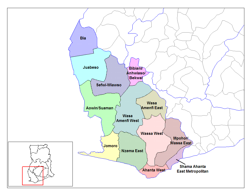
from en:districts of ghana Map of the districts of the Western region of Ghana. Created by Rarelibra for public domain use. Created using MapInfo Professional v7.5 and various mapping resources.
I, the creator of this work, hereby release it into the public domain. This applies worldwide. In case this is not legally possible, I grant any entity the right to use this work for any purpose, without any conditions, unless such conditions are required by law.
* (del) (cur) 08:09, 5 March 2006 . . Rarelibra (Talk | contribs) . . 1056x816 (45,897 bytes) (Map of the districts of the Western region of Ghana. Created by Rarelibra for public domain use. Created using MapInfo Professional v7.5 and various mapping resources.)
Created by Rarelibra for public domain use
Tumidie krataa
| I, the copyright holder of this work, release this work into the public domain. This applies worldwide. In some countries this may not be legally possible; if so: I grant anyone the right to use this work for any purpose, without any conditions, unless such conditions are required by law. |
Kratafa ne ho abakɔsɛm
Mia ɛda/berɛ no so na hwɛ sɛnea krataa no baeɛ wo saa berɛ nom
| Da/Mmere | Tɔfabɔ | Akwan ahodoɔ | Odwumdini | Adwenkyerɛ | |
|---|---|---|---|---|---|
| nea ɛkɔ so | 14:04, 28 Ayɛwohomumɔ 2006 | | 1,056 × 816 (45 KB) | Ahanta | from en:districts of ghana Map of the districts of the Western region of Ghana. Created by Rarelibra for public domain use. Created using MapInfo Professional v7.5 and various mapping resources. I, the creator of this work, hereby release it into the pub |
Nkrataa a wɔde di dwuma
Nea ɛdidisoɔ yi kratafa dwumadie this file:
Nea wiase nyinaa de yɛ adwuma
Wikis a edidi so yi de di dwuma:
- Yɛ de ayɛ adwuma wɔ ca.wikipedia.org
- Yɛ de ayɛ adwuma wɔ ceb.wikipedia.org
- Yɛ de ayɛ adwuma wɔ dag.wikipedia.org
- Yɛ de ayɛ adwuma wɔ de.wikipedia.org
- Yɛ de ayɛ adwuma wɔ en.wikipedia.org
- Aowin/Suaman District
- Shama Ahanta East Metropolitan District
- Wassa West District
- User talk:Rarelibra/Maps2
- List of hospitals in Ghana
- Bia District
- List of Ghana Parliament constituencies
- User:GerardM/Districts of Ghana
- Mpohor/Wassa East District
- Wassa Amenfi District
- Juaboso-Bodi District
- Juaboso-Bia District
- Nzema District
- Sekondi Takoradi Metropolitan Authority
- Wassa-Fiase-Mpohor District
- Aowin-Amenfi District
- Sefwi-Bibiani District
- Yɛ de ayɛ adwuma wɔ eo.wikipedia.org
- Yɛ de ayɛ adwuma wɔ es.wikipedia.org
- Yɛ de ayɛ adwuma wɔ fa.wikipedia.org
- Yɛ de ayɛ adwuma wɔ frr.wikipedia.org
- Yɛ de ayɛ adwuma wɔ fr.wikipedia.org
- Yɛ de ayɛ adwuma wɔ gpe.wikipedia.org
- Yɛ de ayɛ adwuma wɔ ha.wikipedia.org
- Yɛ de ayɛ adwuma wɔ it.wikipedia.org
- Yɛ de ayɛ adwuma wɔ ja.wikipedia.org
- Yɛ de ayɛ adwuma wɔ ko.wikipedia.org
- Yɛ de ayɛ adwuma wɔ la.wikipedia.org
- Yɛ de ayɛ adwuma wɔ nl.wikipedia.org
- Yɛ de ayɛ adwuma wɔ pl.wikipedia.org
View more global usage of this file.