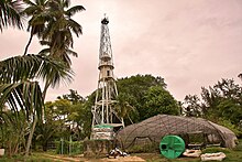
Denis Supɔw (Island)
Denis Supɔw no yɛ supɔw a ɛto so abien a ɛwɔ atifi fam apuei sen biara wɔ Seychelles . Ɛyɛ 60 kilometres (37 mi) wɔ Mahé atifi fam na ɛda Seychelles mpoano atifi fam ano, ne Bird Island a ɛbɛn hɔ, a ɛyɛ Seychelles supɔw a ɛwɔ atifi fam pɛɛ no. Na 1.4 kilomita coral supɔw no, wɔde Franse Po so Asraafo panyin Denis de Trobriand, a ɔhwehwɛɛ mu wɔ 1773 mu no din too so. Denis Supɔw no yɛ ankorankoro dea na ɛwɔ wimhyɛn gyinabea tiawa bi . Ɛwɔ akwamma ahomegyebea a ahɔho adan 23 wom.
| Asase Ho Nsɛm | |
|---|---|
| Beaeɛ (Location) | Seychelles |
| Coordinates | 03°48′13″S 55°40′13″E / 3.80361°S 55.67028°ECoordinates: 03°48′13″S 55°40′13″E / 3.80361°S 55.67028°E |
| Nsupɔw so (Archipelago) | Inner Islands, Seychelles |
| Ɛbɛn (Adjacent to) | Indian Ocean |
| Supɔw Dodoɔ | 1 |
| Nsupɔw akɛse (Major islands) |
|
| Area | 1.4 km2 (0.54 sq mi) |
| Ntwemu (Length) | 1.8 km (1.12 mi) |
| ne tɛtrɛtɛ (Width) | 1.3 km (0.81 mi) |
| Mpoano (Coastline) | 5.2 km (3.23 mi) |
| Adwumayɛ ho nhyehyɛe (Administration) | |
Seychelles
| |
| Ekuo (Group) | Inner Islands |
| Kuw ketewaa bi (Sub-Group) | Northern Coral Group |
| Mansin (Districts) | La Digue and Inner Islands |
| Nnipa a wɔte hɔ kɛse sen biara (Largest settlement) | St. Denis (pop. 80) |
| Nnipa dodow ho Nsɛm (Demographics) | |
| Nnipa dodoɔ (Population) | 80 (2014) |
| Nnipa dodow a wɔdɔɔso (Pop. density) | 57.1/km2 (147.9/sq mi) |
| Mmusuakuw ahorow (Ethnic groups) | Creole, French, East Africans, Indians. |
| Nsɛm foforo a ɛka ho (Additional information) | |
| Ɛhɔ bere (Time zone) |
|
| ISO code | SC-15 |
| Ɔmanfoɔ wɛbsaet (Official website) | www.seychelles.travel/en/discover/the-islands/ |
| Denis Supɔw Kaneadua (Denis Island Lighthouse) | |

| |
| Wɔasisi (Constructed) | 1883 (first), 1910 (current) |
| Adesie (Construction) | metal skeletal tower |
| Ne Tenten (Height) | 27 m (89 ft) |
| Shape (Bɔbea) | 2-stage skeletal tower with balcony and lantern[1][2] |
| Agyiraehyɛde ahorow | white |
| Tumi fibea (Power source) | solar power |
| Focal sorokɔ (Focal height) | 37 m (121 ft) |
| Dodoɔ (Range) | 10 nmi (19 km; 12 mi) |
| Characteristic | <span class="rt-commentedText tooltip tooltip-dotted " title="<nowiki>flashing white light every 5 seconds</nowiki>">Fl W 5s |
Kaneadua bi a wosii wɔ 1910 mu da so ara gyina supɔw no atifi fam ano. Asɔredan bi nso wɔ hɔ a wɔato din Chapel St. Denis.
Supɔw no wɔ akutu nnua, Takamaka ne Casuarina nnua pii. Wɔ afe 2004 mu no, wɔde Seychelles fodies 47 a efi Fregate Supɔw so ne Seychelles warblers 58 a wofi Cousin Supɔw so kɔɔ Denis sɛ Abɔde Seychelles akorae adwuma bi fa.
Wɔakyerɛ supɔw no sɛ cay, wɔ Seychelles Nsupɔw no so.
Hwɛ eyi nso
sesa- Kaneadua a ɛwɔ Seychelles no din
Nneɛma a wɔde kyerɛ
sesa-
Denis Supɔw so Ahomegyebea no asase so kwan a wɔfa so kɔ hɔ, sɛnea wufi wimhyɛn gyinabea hɔ hwɛ no.
-
Denis Supɔw no asase mfonini
Nsɛm a wɔde gyinaa so
sesaAbɔnten so nkitahodi ahorow
sesaNhwɛsoɔ:Lighthouse identifiers
- ↑ Rowlett, Russ. "Lighthouses of Seychelles". The Lighthouse Directory. University of North Carolina at Chapel Hill. Retrieved 2016-09-27.
- ↑ NGA List of Lights – Pub.112 Retrieved 27 September 2016
